Record
1 to
10 of
30
Regional European maps of the Western Europe region from the Maps ETC collection. This includes physical and political maps, early history and empires, WWI maps, climate maps, relief maps, vegetation maps, population density and distribution maps, cultural maps, and economic/resource maps.
|
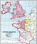
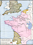
Angevin Dominions,
1154 to 1485
A map showing the possessions of England and France and the dominions dependent on England and France in the 12th Century, after the Norman Conquest and during the Angevin Empire of Henry II and the House of Plantagenet....
|
|
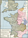
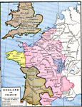
England and France at the accession of Philip Augustus,
1180
A map of England and France at the accession of Philip Augustus in 1180. The map is color–coded to show the Empire of the Plantagenets and Philip Augustus, and indicates territory inherited by Henry II from his mother and father, and acquired f...
|
|
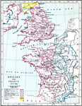
England and France,
1185
A map of England and France in July, 1185. The map is color–coded to show the dominions governed by and dependent on Henry II and the King of France. It also shows the land belonging to Scotland and the Danish or Norse (Isle of Man)....
|
|
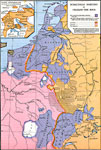
Dominions of the Angevins,
1216
A map showing the dominions of the Angevins in southern England and France in 1216 at the time of Henry III (House of Plantagenet). The map is keyed to show the territories of the Angevins and French, and includes the territories of Flanders, Lothari...
|
|
England and France at the death of Philip Augustus,
1223
A map of England and France at the death of Philip Augustus in 1223. Philip Augustus was a member of the House of Capet, and was responsible for breaking up France's Angevin Empire of the House of Plantagenet. This map is color–coded to show th...
|
|
England and France during the first English invasion of France,
1337–1360
A map of England and France during the first English invasion of France from Edward III in 1337 to the Treaty of Brétigny in 1360. The map is color–coded to distinguish English land from French land, and the boundary of the British realm...
|
|
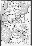
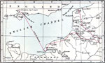
Henry V's First Campaign in France,
1415
A map of Henry V's first campaign in France in the year 1415. The map shows his path from departure in Southampton to Portsmouth (August 9), across the English Channel to Chef de Caux, and his overland route and eventual arrival in Calais (October 29...
|
|
Burgundian Dominion of Charles the Bold,
1467–1477
A map of the Burgundian Dominion of Charles the Bold in 1477. The map is color–coded to show countries directly ruled by Charles, as well as land controlled by Loraine, France, and the Empire. The inset map details central Switzerland and the s...
|
|
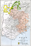
Savoy,
1601
A map of Savoy (Duchy of Savoy) in 1601 at the time of the Treaty of Lyon. This map is color–coded to show areas ceded to France (Bresse and Burgundy), territories lost to Switzerland (1475–1601), and the territories acquired from Italy b...
|
|
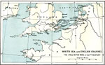
North Sea and the English Channel,
1652–1674
A map of the North Sea and the English Channel, subtitled "The Anglo–Dutch Wars of the 17th Century." This map shows the coastal features and major cities during the Anglo–Dutch Wars, a series of three wars to establish control...
|
Maps
is a part of the
Educational Technology Clearinghouse
Produced by the
Florida Center for Instructional Technology
© 2009
College of Education
,
University of South Florida