Record
311 to
316 of
316
A collection of world and multi-continent maps, including various projections, hemispheric maps, physical and political maps, early known world maps, climate maps, relief maps, ocean current maps, population density and distribution maps, vegetation maps, and economic/resource maps.
|
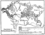
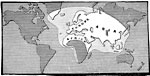
Distribution of Carboniferous Rocks,
359 Ma. to 299 Ma.
This is a global map from 1910 showing the distribution of Carboniferous Period rocks. This map shows the land areas of Gondwana and Angara (Siberian craton), areas in which Older Marine Carboniferous Rocks are known, areas in which Younger Marine C...
|
|
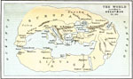
The World according to Hecatæus,
500 BC
A facsimile of the map of the world according to Hecatæus (500 BC), around the time of the Persian invasion of the Greek mainland, and shows the extent of early European knowledge of the earth. This map highlights the importance of navigation t...
|
|
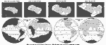
Progression of European Knowledge of the World,
500 BC to AD 1900
A map from 1901 showing the regions of the world known to Europeans at various points in time. This series of maps shows the progression of geographic discovery by Europeans from the time of the Greeks adding England and India to their maps (500 BC),...
|
|
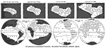
The Progress of Geographical Discovery,
500 BC to AD 1900
A map from 1898 showing the regions of the world known to Europeans at various points in time. This series of maps shows the progression of geographic discovery by Europeans from the time of the Greeks adding England and India to their maps (500 BC),...
|
|
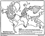
Distribution of Cambrian Rocks,
542 Ma. to 489 Ma.
This is a global map from 1910 showing the distribution of Cambrian Period rocks. This map shows areas in which marine deposits are known, areas gained by the Sea between the beginning and close of the Cambrian Period, and areas of unknown distributi...
|
|
The Part of the World Known at the time of Columbus,
Late 1400s
A map from 1907 showing the extent of the European's known world in the time of Christopher Columbus (1451–1506), which reflects the explorations of the Norsemen (around AD 1000), travels of Marco Polo to China (1271–1295), and Vasco de G...
|
Maps ETC is a part of the Educational Technology Clearinghouse
Produced by the Florida Center for Instructional Technology © 2009
College of Education, University of South Florida