Maps Site map
  Maps > Globes & Multi-Continent > Regional Maps >Regional Americas
Site Map  

  Record   1   to   10  of   40

Regional Globes & Multi-Continental maps of the Regional Americas region from the Maps ETC collection. This may include physical and political maps, early history and empires, climate maps, relief maps, vegetation maps, population density and distribution maps, cultural maps, and economic/resource maps.

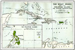
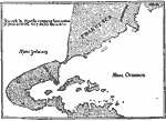
The West Indies and the Philippine Islands ,
Map showing the West Indies and the Philippine Islands, subtitled "The Spanish American War." Map is color–coded to show islands ceded to the U.S. ...

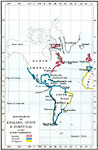
Discoveries of England, Spain and Portugal, 1400–1599
Map showing the discoveries of land in the new world by England, Spain and Portugal in the 15th and 16th centuries....

European Exploration of the Americas, 1492–1522
A map of the Americas showing the routes taken by early European explorers from the four voyages of Columbus (1492–1502) to the voyage of Juan Bermudez (1522). The map is color–coded to show the regions explored by the Portuguese, Spanish...

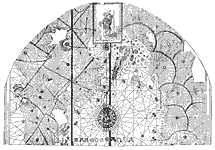
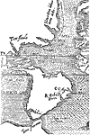
La Cosa Map of North and South America, 1500
Juan de la Cosa's depiction of the Spanish and Portuguese discoveries of the New World....

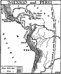
Conquest of Mexico and Peru, 1519–1530
A map of Central and South America showing the extent of the Aztec and Inca empires, and the routes of Hernando Cortez (conquest of the Aztec Empire, 1519) and Francisco Pizarro (conquest of the Inca Empire, 1530). The map shows the "Pope's Line...

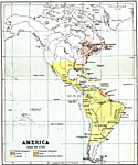
European Colonization of the Americas, 1522–1700
A map of the Americas showing the land claims or possessions of Britain, France, Spain, Portugal, and Holland in the western hemisphere between 1522 and 1700. The map shows the period roughly from the conquest of Mexico by Cortez to the territorial r...

Thorne's Map of the New World, 1527
Depiction of North and South America, and surrounding oceans, in 1527. ...

The Maiollo Map of the Americas, 1527
A facsimile copied from the chart made by the brother of Giovanni de Verrazano in 1527, after the 1524 expedition to New York Bay. The map shows Lavoradore (Labrador), Cortereal (the lands explored by the Portuguese João Vaz Corte–Real),...

Part of Orontius Fine's Globe, 1531
Mercator's Projection of the Globe in 1531....

Part of Sebastian Cabot Mappe Monde, 1544
A facsimile of an early map showing North and South America in 1544....

Next Last


  Maps > Globes & Multi-Continent > Regional Maps >Regional Americas
Site Map  

Maps is a part of the Educational Technology Clearinghouse
Produced by the Florida Center for Instructional Technology © 2009
College of Education , University of South Florida