Maps Site map
  Maps > United States > Early America 1400-1800
Site Map  

  Record   111   to   120  of   143

A collection of historic maps of early America from explorations and settlements of the English, French, and Spanish, to the end of the American Revolutionary War.

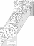
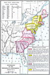
The Colonies During the American Revolution, 1775–1783
A general map of the Colonies during the American Revolutionary War showing significant battle sites in the region from the Hudson River Valley south to Savannah....

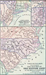
The Routes of the British Army in the Revolutionary War, 1775–1783
A series of three maps showing the routes of the British Army during the Revolutionary War. The upper left map details the Lower Hudson, Connecticut, Rhode Island, New Jersey, and Pennsylvania region, the upper right map details Lake Champlain and up...

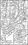
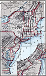
Campaigns in the North — The Revolutionary War, 1775–1783
A series of maps showing the northern campaigns of the American Revolutionary War, including the Hudson Valley and Saratoga campaign, a detail of Ticonderoga, the vicinity of Burgoyne's surrender, the Battle of Long Island, and an over–view map...

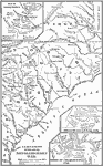
Campaigns in the South — The Revolutionary War, 1775–1783
A map of the portions of Virginia, North Carolina, South Carolina, and Georgia involved in major campaigns of the American Revolutionary War. The map shows cities, towns, and forts, rivers and terrain features, and is keyed to show British and Americ...

American Revolutionary War Campaigns in the North, 1775–1783
A map of the region involved in major northern campaigns of the American Revolutionary War. The map shows cities, towns, and forts, rivers and terrain features, and is keyed to show British and American routes during the campaigns. An inset map detai...

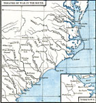
Theatre of the American Revolutionary War in the South, 1775–1783
A map of the southern theater of the American Revolutionary War from the Chesapeake Bay south to Savannah, showing major cities and towns, forts, and important battle sites of the period. An inset map details Yorktown, site of the final battle of the...

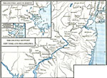
Areas of the Northern American Revolutionary War, 1775–1783
A series of maps showing the country around Boston, the immediate vicinity of Boston, and the country between New York City and Philadelphia during the American Revolutionary War period. These maps show cities and towns, forts, rivers, and important ...

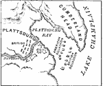
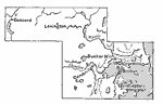
Plan of the Battle of Lake Champlain, 1776
Colonial New York area where the Battle of Lake Champlain took place. ...

Accessions to the Principal of Independence, 1776
A map of the Thirteen Colonies color–coded to show the accessions to the principal of Independence before July 2, 1776. The map shows when the colonial delegates to the Continental Congress were instructed to vote on the Declaration of Independ...

The First Battlegrounds of the Revolution, 1776
A map of the area around Boston, from Concord to Dorchester Heights, showing the sites of the first battles of the American Revolution in 1776....

First Previous Next Last


  Maps > United States > Early America 1400-1800
Site Map  

Maps ETC is a part of the Educational Technology Clearinghouse
Produced by the Florida Center for Instructional Technology © 2009
College of Education, University of South Florida