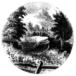
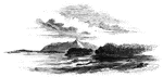
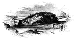
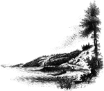
William's Rock
William's Rock. This view is taken from the road, looking northward. In the distance is seen the highest…
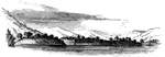
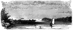
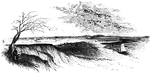
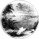
Long Point
Long Point and vicinity. This little sketch was taken from the steam-boat , near the south end of Long…
Sabbath Day Point
Sabbath Day Point. It is between three and four miles from the little village of Hague, in the midst…
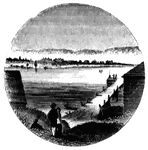
Roger's Rock
Roger's Rock. This sketch is from the lake, a little south of Cook's Point, seen just over the boat…
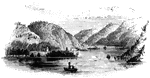
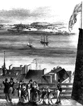
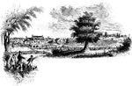
Sholes's Landing
View from Shole's Landing. This is a view from Chipman's Point, or Sholes's Landing, looking north.…
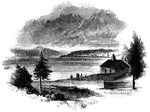
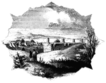
Chimney Point
Chimney Point Landing. This view is taken from the green in front of the inn at Chimney Point, looking…
Arnold's Battle
Scene of Arnold's naval battle. This sketch was made from the pilot's room of the steam-boat just after…
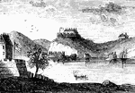
Beloeil Mountain
Beloeil Mountain, this sketch is taken from the southeast angle of old Fort chambly, showing the rapids…
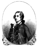
Sir Guy Carleton
Sir Guy Carleton, afterward Lord Dorchester, was Wolfe's quartermaster at the storming of Quebec, and…
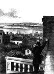
Point Levi
View of Point Levi from Durham Terrace, Quebec. This sketch is taken from Durham Terrace, near the north…
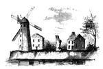
Wind-Mill Point
Wind-mill Point. This view was sketched from the steam-boat, when a little below the wind-mill, looking…
Oswego Harbor
View of Oswego Harbor, 1848. This view is from the top of the United States Hotel, looking east-northeast.…
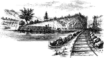
Little Falls
View at Little Falls. This view was taken from the rail-road near the village, looking down the river.…
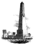
Caldwell's Monument
Caldwell's monument. The following are the inscriptions upon the Caldwell monument: East Side: "This…
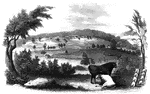
Bennington Battle-ground
The Bennington battle-ground. This view is from the hill on the southwest bank of the Walloomscoick,…
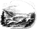
Compo
Distant view of Compo. This view is from the top of a high hill northeast of the dwelling of Mr. Ebenezer…
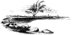
Fitch's Point
Fitch's Point, the landing-place of the British. This view is from the west side of Gregory's Point,…
Charlestown
"Charlestown in 1775. No. 1 is Bunker Hill; 2, Breed's Hill; 3, Moulton's Point; 4, a causeway near…
Arnold Landing-place
"View of the landing-place of Arnold. This sketch is from the west side of the cove in which the troops…
Williams landing-place
"Landing-place of Roger Williams. This view is on the left bank of the Seekonk, looking south. The point…
Gaspee Point
"Gaspee Point. This view is from the bank of the cove just below the Point, looking northeast, showing…

Plum Point
"Remains of fortifications at Plum Point. This view is from the interior of the redoubt looking eastward…
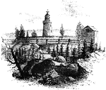
West Point
"West Point in 1780. This view is from a print published in the New York Magazine for 1790.…
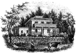
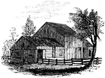
Smith's House
"Smith's House. This view is from the slope in front of the house. The main building is of stone; the…
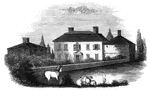
Beverly Dock
"View at Beverly Dock. This view is taken from the Hudson River rail-road, looking north. The dock,…
Fort Montgomery
"View near Fort Montgomery. This view is from an eminence near the mountain road, about three quarters…
Peekskill Landing
"View from Peekskill Landing. This view is from Peekskill landing, looking up the river. On the left…
Stony Point
"Rear view at Stony Point. This sketch presents a rear view of the old embankments of the fort, and…
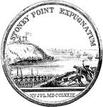
Wayne Medal Back
"Gold medal awarded by Congress to General Wayne. This is a representation of the medal, the size of…
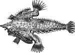
Bat Malthea
"Is ten to eighteen inches long, pale grayish-brown, snout elongated into a point, skin like shagreen,…

Stewart Medal Back
"Medal awarded to Major Stewart. This represents the medal the size of the original. On the back side…
Jameson's Head-quarters
"Colonel Jameson's head-quarters. This is a view of the out-buildings of Mr. Sands, at North Castle,…
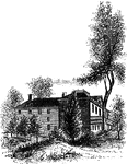
Livingston Mansion
"The Livingston Mansion. This is a view from the lawn on the north side. It is embowerd in trees and…
Monmouth Battle-Ground
"Battle-ground at Monmouth. This view is from the orchard, upon the site of Wayne's position when Monckton…
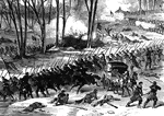
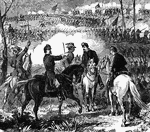
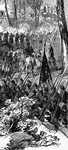
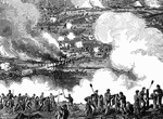
Battle of Stone River
"Battle of Stone River, Tenn. The decisive charge of General Negley's division across the river- the…
Battle of Stone River
"Battle of Stone River, Tenn. The decisive charge of General Negley's division across the river- the…
Battle of Stone River
"Battle of Stone River, Tenn. The decisive charge of General Negley's division across the river- the…
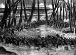
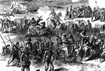
Battle of Pea Ridge
"Battle of Pea Ridge, Ark., fought March 6th, 7th and 8th, 1862, between the Federal forces, 13,000…
Battle of Pea Ridge
"Battle of Pea Ridge, Ark., fought March 6th, 7th and 8th, 1862, between the Federal forces, 13,000…
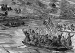
The Forlorn Hope
"'The Forlorn Hope.' Volunteers storming party, consisting of portions of the Seventh Michigan and Nineteenth…
The Forlorn Hope
"'The Forlorn Hope.' Volunteers storming party, consisting of portions of the Seventh Michigan and Nineteenth…
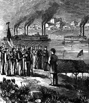
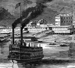
Bellaire
"Bellaire, O.- Steamboats conveying troops and munitions of war for the Federal forces on the Great…
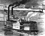
Bellaire
"Bellaire, O.- Steamboats conveying troops and munitions of war for the Federal forces on the Great…
Bellaire
"Bellaire, O.- Steamboats conveying troops and munitions of war for the Federal forces on the Great…
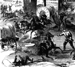
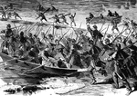
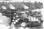
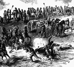
Battle of White Oak Swamp Bridge
"Battle of White Oak Swamp Bridge, Monday June 30th, 1862- Ayres's, Mott's and Randall's batteries checking…
Battle of White Oak Swamp Bridge
"Battle of White Oak Swamp Bridge, Monday June 30th, 1862- Ayres's, Mott's and Randall's batteries checking…
Battle of White Oak Swamp Bridge
"Battle of White Oak Swamp Bridge, Monday June 30th, 1862- Ayres's, Mott's and Randall's batteries checking…
Battle of White Oak Swamp Bridge
"Battle of White Oak Swamp Bridge, Monday June 30th, 1862- Ayres's, Mott's and Randall's batteries checking…
Loligo brevipinna
"A small species, the body three to four inches long, beak prominent and horny; the long arms slender,…
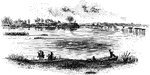
James River
"Scene on the James River, at Richmond. This view is from a long shaded island extending up the river…
Jamestown Island
"Distant view of Jamestown Island. This view is from the north side of what was once a marsh, but now…
Redoubt
"View from the site of the Redoubt. This view is from the mounds looking northwest, up the York River.…
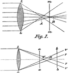
Aberration
"In optics, a deviation in the rays of light when unequally refracted by a lens or reflected…
Trading Ford
"Trading Ford. This view of the Trading Ford, where greene, with Morgan and his light troops, crossed…
Guilford Battle-ground
"View of the battle-ground. This view is from the eminence southwest of the site of old Guilford Court…