Record
41 to
50 of
121
Historic and contemporary maps of Europe, including physical and political maps, early history and empires, WWI maps, climate maps, relief maps, vegetation maps, population density and distribution maps, cultural maps, and economic/resource maps.
|
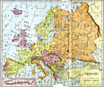
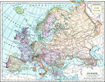
Europe,
1897
Map of Europe....
|
|
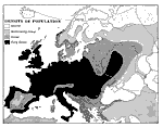
Density of Population of Europe,
1898
A map showing the Density of Population of Europe in 1898. "Europe, though little larger than the United States, contains five times as many inhabitants, and hence is much more densely peopled...Europe is composed of twenty or more independent s...
|
|
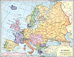
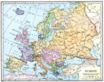
Europe,
1898
A map showing Europe in 1898. "Europe is composed of twenty or more independent states or countries, in nearly every one of which the people differ from those of others in language, customs, and standards of living...In Europe [there are] two im...
|
|
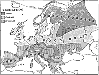
Vegetation in Europe,
1898
A map showing Vegetation in Europe as of 1898. "The great agricultural regions are (1) the northern lowland from the Atlantic eastward through southern Russia, and (2) the broad fertile valleys of the Danube, the Po, the Rhone, and the streams o...
|
|
Europe,
1899
A map showing country boundaries of Europe as they existed in 1899, including major cities, rivers, and railroad routes. This map also includes an outline map of Colorado for area size comparison. ...
|
|
Europe,
1901
A map showing country boundaries of Europe as they existed in 1901, including major cities, rivers, and railroad routes....
|
|
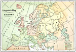
Linguistic Map of Europe,
1901
A linguistic map showing the regional identification of language groups spoken in Europe, including Celtic, Teutonic, Slavonic, Romance, Hellenic, and Turanian....
|
|
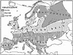
Vegetation Map of Europe,
1901
A sketch map from 1901 of Europe showing the general agriculture or vegetation types in the region. This map is keyed to show areas which are predominately forest, the great food belt, and the great grape belt. "The great agricultural regions ar...
|
|
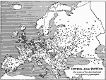
Cities and Towns of Europe,
1901
A sketch map from 1901 of Europe, showing the distribution of cities and towns in the region at the time. The size of the dots indicate the comparative populations....
|
Maps ETC is a part of the Educational Technology Clearinghouse
Produced by the Florida Center for Instructional Technology © 2009
College of Education, University of South Florida
