Record
91 to
100 of
316
A collection of world and multi-continent maps, including various projections, hemispheric maps, physical and political maps, early known world maps, climate maps, relief maps, ocean current maps, population density and distribution maps, vegetation maps, and economic/resource maps.
|
July Isobars,
1896
A world map from 1896 showing typical global isobars and winds during July. This map is color–coded to show the areas of high barometric pressure in pinks, and areas of low barometric pressure in blues. Barometric pressures are shown on the iso...
|
|
Mean Global Annual Rainfall,
1896
A map of the Earth from 1896, showing the average distribution of annual rainfall (precipitation) over the land surface, from areas where less than 10 inches fall annually to areas where an excess of 75 inches fall....
|
|
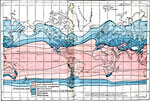
Global Rainfall Seasons,
1896
A world map from 1896 showing seasonal rainfall distribution over the globe. This map is color-coded to show the major subdivisions, including the region of tropical rainfall (light pink), subtropical rainfall (dark blue), transition regions (dark pu...
|
|
Global Heat Zones,
1896
A world map from 1896 showing the heat zones of the Earth, according to the duration of the hot, temperate, and cold periods. The map is color–coded to show the Tropical Zone, Sub–tropical Zone, Temperate Zone (including zones of constant...
|
|
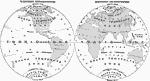
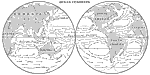
Western Hemisphere, Eastern Hemisphere,
1897
A Map of the Western and Eastern hemispheres from 1897 showing the frigid, temperate, and torrid zones of the earth based on latitudes north of the Arctic and south of the Antarctic circles (Frigid zones), to the tropics of Cancer and Capricorn (Temp...
|
|
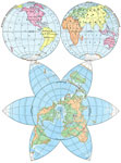
Star-Shaped and Hemisphere Maps of the Earth,
1898
A world map from 1898, showing the earth as East Hemisphere and West Hemisphere at the top, and showing the "Continental Plateau" in the star–shaped map below. The hemisphere maps use the mapping convention of dividing the earth, boun...
|
|
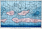
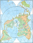
Star-Shaped Map of the Earth with Polar Projection,
1898
A star–shaped world map from 1898 showing the earth from a northern polar perspective, with the equator circling the body of the star. This map is color–coded to show general highlands and lowlands, the areas around the Caspian Sea and Re...
|
|
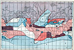
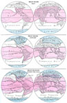
Climate, True Heat Belts,
1898
This is a map from 1898 showing seasonal worldwide heat belts during July (top) and January (middle), with a combined map showing overall heat changes during the year (bottom). "The boundaries of the true heat belts in January and in July are sh...
|
|
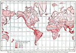
Winds and Rainfall,
1898
This is a map from 1898 of winds and rainfall over the Earth. "Like nearly all other substances, the air [in the atmosphere] expands and occupies more space when heated. If the atmosphere over any region becomes warmer then that over surrounding...
|
|
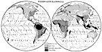
Ocean Currents,
1898
This is a map from 1898 of ocean currents over the earth. "In nearly every part of the sea there are slow movements, or currents, of the surface water. The currents move in the general directions of the prevailing winds, and are generally believ...
|
Maps ETC is a part of the Educational Technology Clearinghouse
Produced by the Florida Center for Instructional Technology © 2009
College of Education, University of South Florida