Hooded Merganser
Measuring about nineteen inches long, the hooded merganser is common in North America, its head adorned…
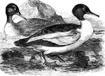
Goosander
Found in both Europe and North America, the goosander is also known as the buff-breasted sheldrake,…
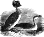
Sclavonian Grebe
Also known as the horned grebe, dipper, water-witch, and hell-diver, the sclavonian grebe is common…
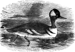
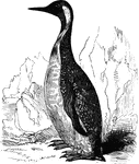
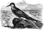
Red-throated diver
"The red-throated diver, twenty-four inches long, is common to Europe and America. This is called scape-grace…
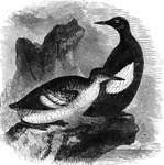
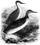
Black Guillemot
Found in the arctic regions of Europe and America, the black guillemot averages about thirteen inches…
King Penguin
Also known as the pantagonian penguin, the king penguin is found in the far southern latitudes of South…
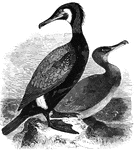
Black cormorant
The black cormorant averages about three feet in length, and is found in Greenland, as well as a long…
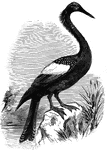
Anhinga
Also known as the snake-bird, the anhinga inhabits the freshwater areas of the South Atlantic States;…
Matamata tortoise
Primarily nocturnal, the matamata tortoise of South America feeds on small reptiles and fish.
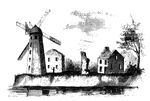
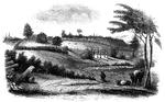
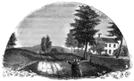
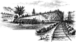
Wind-Mill Point
Wind-mill Point. This view was sketched from the steam-boat, when a little below the wind-mill, looking…
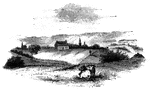
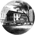
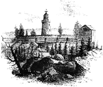
Oswego
Oswego in 1755. This view is looking north toward the lake. It is a reduced copy of the frontispiece…
Guy Park
This was the residence of Colonel Guy Johnson, and is still standing, on the north side of the Mohawk,…
Oriskany
The battle-ground of Oriskany. This sketch was made from the eastern side of the ravine, looking west.…
Old Parsonage and Church
Old Parsonage and Church. This view is from the high plain on the right of the block-house, looking…
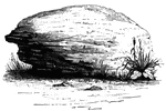
Brant's Rock
Brant's Rock. This rock, which is about four feet high, lies in a field on the left of the road leading…
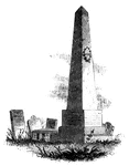
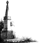
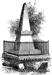
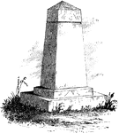
Caldwell's Monument
Caldwell's monument. The following are the inscriptions upon the Caldwell monument: East Side: "This…
Steuben's Head-Quarters
Steuben's head-quarters. This view is from the field in front of the house, looking north. The dwelling…
![The Yeoman House. This view is from the road, looking north. An attempt was made by a soldier to burn the house, but so rapid was the march of the invaders that the flames had made but little progress before the troops were far on their road to the village. An [African American] woman, who was concealed under some corn-stalks near, extinguished the flames. The house is about half a mile from the river, on the right side of the road from the landing to Kingston village.](https://etc.usf.edu/clipart/13500/13510/yeoman_13510_mth.gif)
Yeoman House
The Yeoman House. This view is from the road, looking north. An attempt was made by a soldier to burn…
Bennington Battle-ground
The Bennington battle-ground. This view is from the hill on the southwest bank of the Walloomscoick,…
Agnew and Erskine
Head-quarters of Agnew and Erskine. This house is on the south bank of Still River, at the north end…
Ridgefield
Place of the barricade, Ridgefield. This view is at the north end of the main street. It was taken from…
Fitch's Point
Fitch's Point, the landing-place of the British. This view is from the west side of Gregory's Point,…
Common iguana
A large lizard, the common iguana is common to the tropical regions of the Americas. It spends much…


Pine-Tree Shilling
The Pine-Tree Shilling. This is a fac-simile of the first money coined in America. The mint-master,…
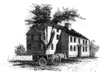
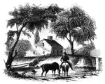
Barrett's House
"Colonel Barrett's House. This sketch is from the road leading to the village of Concord by the way…
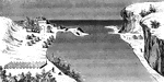
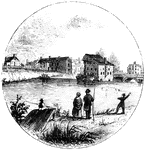
New London Harbor
"New London Harbor, looking north. This little sketch shows the relative position of the forts. Fort…
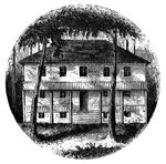
Providence Tavern
"Old Tavern in Providence. This view is from the market, looking north. The building stands on the east…
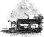
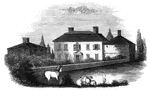
Hubbard's House and Mill
"Hubbard's House and Mill. The inscriptions upon the monument are as follows: East Side: "Oliver Hazard…
Goshen Monument
"Monument at Goshen. During the battle, Major Wood, of Goshen, made a masonic sign, by accident, which…
West Point
"West Point in 1780. This view is from a print published in the New York Magazine for 1790.…
Beverly Dock
"View at Beverly Dock. This view is taken from the Hudson River rail-road, looking north. The dock,…
Stony Point
"Rear view at Stony Point. This sketch presents a rear view of the old embankments of the fort, and…
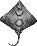
Skate
"It is very voracious, and grows to large size. Found in the European and American waters" — Goodrich,…
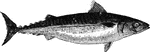
Common Mackerel
"Eaten both fresh and salted, and is caught in immense numbers in Europe and America. It is fourteen…
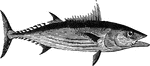
Bonito
"Resembles the tuna in form, but is seldom more than thirty inches long. It is extensively distributed,…
Dealfish
"Four to six feet long, breadth eight inches, thickness one inch; found in the North Atlantic, and has…
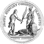
Stewart Medal Front
"Medal awarded to Major Stewart. This represents the medal the size of the original. The device is America…
Jameson's Head-quarters
"Colonel Jameson's head-quarters. This is a view of the out-buildings of Mr. Sands, at North Castle,…
Van Wart's Monument
"Van Wart's monument. The following are the inscriptions upon this monument: North Side: 'Here repose…
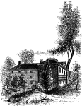
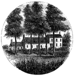
Livingston Mansion
"The Livingston Mansion. This is a view from the lawn on the north side. It is embowerd in trees and…
Ramapo Pass
"Remains of intrenchments the Ramapo Pass. This view is from the road, looking north toward the village…
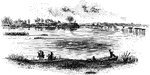
Trenton
"Trenton Bridge and vicinity. This view is from the north side of the Assanpink, a few rods above the…
Princeton battle-ground
"View of the battle-ground near Princeton. This view, looking north, is from the carriage gate of Mr.…
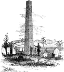
Treaty Monument
"Treaty Monument. This monument stands near the intersection of Hanover and Beach Streets, Kensington,…
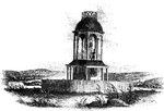
Observatory
"The observatory. This view is from the field, looking north. On the left is seen the winding Schuylkill,…
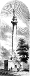
Washington Monument
"Washington Monument. The following are the inscriptions on the monument: East front: 'To George Washington,…
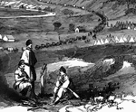
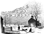
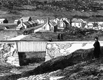
Strasburg Lookout
"View of the town of Strasburg, valley of the Shenandoah, occupied by the Federal forces under General…
Bridge at Strasburg
"View of the town of Strasburg, valley of the Shenandoah, occupied by the Federal forces under General…
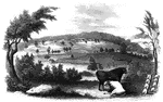
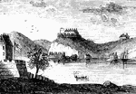
Jamestown Island
"Distant view of Jamestown Island. This view is from the north side of what was once a marsh, but now…
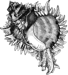
Murex regius
"The M. regius is found on the west coast of Central America, and suprasses all power of description…
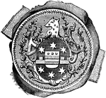
William Tryon Seal
"Seal and signature of Tryon. William Tryon was a native of Ireland, and was educated to the profession…
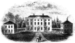
Tryon Palace
"Front view of Tryon's Palace. The view here given was the north front, toward the town. The center…

Regulator Battle-ground
"The Regulator battle-ground. This view is from the south side of the Salisbury Road, which is marked…
Guilford Battle-ground
"View of the battle-ground. This view is from the eminence southwest of the site of old Guilford Court…
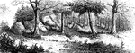
King's Mountain Battle-Ground
"View at King's Mountain battle-ground. This view is from the foot of the hill, whereon the hottest…