Record
181 to
190 of
316
A collection of world and multi-continent maps, including various projections, hemispheric maps, physical and political maps, early known world maps, climate maps, relief maps, ocean current maps, population density and distribution maps, vegetation maps, and economic/resource maps.
|
Map of the World on the Equivalent Projection,
1911
A world map from 1911 showing the earth on an Equivalent Projection (preserves relative size of areas, but distorts shape, particularly in the higher latitudes). The map shows national borders, major cities, and submarine cable routes. "This new...
|
|
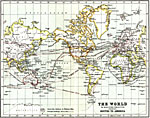
The World, Showing Routes to America,
1911
A world map from 1911 on a Mercator's Projection, showing commercial routes to North and South America. The map shows principal railways and steamship routes with distances between ports given in nautical miles....
|
|
Voyages and Discoveries,
1912
A world map from 1912 showing the voyages and routes of exploration of Europeans, including dates of ‘discoveries.’ The map is color-coded to show the territories explored and claimed by the Spanish in orange, and by the Portuguese in gre...
|
|
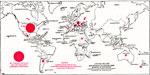
World Distribution of Corn Production,
1912
A map from 1912 showing the world distribution of corn production according to the United States Department of Agriculture, Bureau of Statistics. The average annual total corn production of all countries from which data are obtainable at the time is ...
|
|
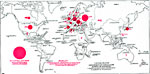
World Distribution of Oat Production,
1912
A map from 1912 showing the world distribution of oat production according to the United States Department of Agriculture, Bureau of Statistics. The average annual total oat production of all countries from which data are obtainable at the time is 3,...
|
|
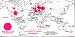
World Distribution of Barley Production,
1912
A map from 1912 showing the world distribution of barley production according to the United States Department of Agriculture, Bureau of Statistics. The average annual total barley production of all countries from which data are obtainable at the time...
|
|
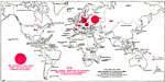
World Distribution of Rye Production,
1912
A map from 1912 showing the world distribution of rye production according to the United States Department of Agriculture, Bureau of Statistics. The average annual total rye production of all countries from which data are obtainable at the time is 1,...
|

|
World Distribution of Flaxseed Production,
1912
A map from 1912 showing the world distribution of flaxseed production according to the United States Department of Agriculture, Bureau of Statistics. The average annual total flaxseed production of all countries from which data are obtainable at the ...
|
|
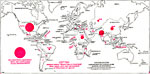
World Distribution of Cotton Production,
1912
A map from 1912 showing the world distribution of cotton production according to the United States Department of Agriculture, Bureau of Statistics. The average annual total cotton production of all countries from which data are obtainable at the time...
|
Maps ETC is a part of the Educational Technology Clearinghouse
Produced by the Florida Center for Instructional Technology © 2009
College of Education, University of South Florida