Record
61 to
70 of
316
A collection of world and multi-continent maps, including various projections, hemispheric maps, physical and political maps, early known world maps, climate maps, relief maps, ocean current maps, population density and distribution maps, vegetation maps, and economic/resource maps.
|
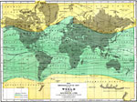
Hyetographic or Rain Map of the World,
1890
A Hyetographic or rain map of the world from 1890. The map shows the northern and southern limits of snowfall, the latitudes of the Arctic Circle and tropics of Cancer and Capricorn, and specific cities with figures indicating inches of annual precip...
|
|
Meteorological Map of the World,
1890
A meteorological map of the world from 1890 showing the mean annual temperature of the air at the earth's surface. The map is color–coded to show regions where the mean annual temperature is above freezing and regions where it is below freezing...
|
|
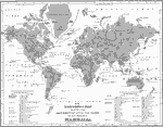
Zoological Map of Mammalia,
1890
A world map from 1890 showing the distribution of principal or representative species of mammalia across the globe. The map divides the world into the Western Continent (North and South America) and the Eastern Continent (Europe, Asia, Africa, and Au...
|
|
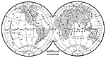
Globular Projection of the Earth,
1890
This is a globular projection of the earth from 1890. In order to show the spherical earth on a flat map, some distortions are inevitable. Globular map projections provide accurate relative sizes of landmasses, but direction is distorted. ...
|
|
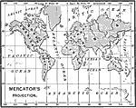
Mercator's Projection of the Earth,
1890
This is Mercator's projection of the earth from 1890. In order to show the spherical earth on a flat map, some distortions are inevitable. In Mercator's projection, "The directions are correct, but the size of the countries is distorted, the rel...
|
|
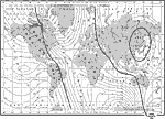
Volcanoes and Earthquakes,
1890
This map from 1890 shows areas of volcanic and seismic activity throughout the world. Areas of particular interest are shown on a larger scale. The world map shows volcanoes grouped in lines along mountain ranges with a heavy black line, and volcanoe...
|
|
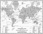
Magnetic Chart of the World,
1890
A world map from 1890 showing the Earth's east-west declination of the magnetic poles from the geographic poles. In order to properly read a compass, variations in the location of magnetic north from the observer's current location must be taken into...
|
|
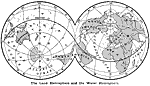
The Land Hemisphere and the Water Hemisphere,
1890
"The portions of the land —the continents and the islands— are very irregular in shape, and are unequally distributed over the globe. By far the greater portion of the land lies north of the equator. There are also what are called a ...
|
|
Global Drainage Basins and Winds,
1890
A world map from 1890 showing the major drainage basins of the earth, and prevailing wind patterns. This map is color-coded to show the drainage basins of the Atlantic, the Pacific and Mediterranean, the Arctic Ocean, the Gulf of Mexico, Caribbean, B...
|
Maps ETC is a part of the Educational Technology Clearinghouse
Produced by the Florida Center for Instructional Technology © 2009
College of Education, University of South Florida