Record
181 to
190 of
228
A collection of historic and contemporary maps of England, Scotland, and Wales, including historic divisions, empires and kingdoms, detailed travel maps, climate maps, population density and distribution maps, vegetation maps, and economic/resource maps.
|
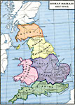
Roman Britain,
A.D 369
Map of Roman Britain about AD 369 showing the provinces of Britannia Prima, Flavia Caesariensis, Britannia Secunda, Maxima Caesarensis, and Valentia. The map shows important cities of the time with Latin names and modern names italicized, including L...
|
|
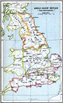
Anglo-Saxon Britain "The Heptarchy",
A.D. 500–850
A map of Anglo–Saxon Britain after the departure of the Roman Legion during a period known as the Heptarchy, or Seven Kingdoms (AD 500–850). The map is color–coded to show the territories of Strathclyde, Northumbria, Mercia, East An...
|
|
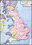
Celtic Britain about the Birth of Christ,
about A.D. 1
Map of Celtic Britain about the birth of Christ. This map is color–coded to differentiate between the Ivernians, Goidels or Gaels, and Brythans or Gauls. The names of Celtic tribes are shown, as well as rivers, coastal features, and the locatio...
|
|
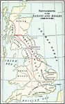
Settlements of the Saxons and Angles,
AD 449–626
A map of Scotland, England and Wales showing the settlements of the Saxons and Angles from the landing of Hengist and Horsa at Ebbsfleet on the shores of the Isle of Thanet (AD 449) to the Saxon Heptarchy (AD 626). "By these invasions the follow...
|

|
The Saxon Invasion of Kent,
AD 450
A map of northeast Kent and the Thames Estuary at the time of the Saxon invasions, around AD 450. The map is color–coded to show the territories of the Britons in pink, the Saxons in orange, and the Angles in green. Although the Romans departed...
|

|
England during the Saxon Period,
AD 450–1066
A map of England, Wales, and southern Scotland during the Saxon Period from around AD 450 to the beginning of the Norman Conquest in 1066. This map shows major cities of the time, major river ways, topography, and is color–coded to show the ter...
|

|
Scotland and Northern England during the Saxon Period,
AD 450–1066
A map of Scotland and North Britain during the Saxon Period from around AD 450 to the beginning of the Norman Conquest in 1066. This map shows major cities of the time, major river ways, topography, battlefields, and political boundaries. Scale in En...
|

|
Britain,
AD 500
A map of Britain about AD 500. This map is color–coded to show the territories of the Celtic tribes, the Jutes since 449, the Saxons since 477, and the English since 490. The map shows important cities and ports of the time, labeled with their ...
|

|
England,
AD 550
A map of England and Wales in AD 550, after the departure of the Romans (AD 410) and during the migration of the Angles, Saxons, and Jutes from Europe. The map is color–coded to show the territories of the native Britons or Welsh, Angles, Saxon...
|
|
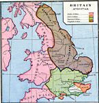
Britain,
AD 577
A map of Britain after AD 577 and the Anglo–Saxon migration. This map is color–coded to show the territories of the Celtic tribes, the Jutic tribes, the Saxons tribes, and the English tribes. The map shows important cities and ports of th...
|
Maps ETC is a part of the Educational Technology Clearinghouse
Produced by the Florida Center for Instructional Technology © 2009
College of Education, University of South Florida