Maps Site map
  Maps > Globes and Multi-continent > Complete Maps
Site Map  

  Record   211   to   220  of   316

A collection of world and multi-continent maps, including various projections, hemispheric maps, physical and political maps, early known world maps, climate maps, relief maps, ocean current maps, population density and distribution maps, vegetation maps, and economic/resource maps.

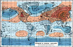
Global Isobars and Winds - January, 1915
A world map from 1915 showing typical global isobars and winds during January. This map is color–coded to show the areas of high barometric pressure in tans, and areas of low barometric pressure in blues. The dark blue color indicates areas of ...

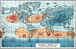
Isobars and Winds - July, 1915
A world map from 1915 showing typical global isobars and winds during July. This map is color–coded to show the areas of high barometric pressure in tans, and areas of low barometric pressure in blues. The dark blue color indicates areas of pre...

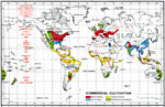
Global Commercial Cultivation, 1915
A world map from 1915 showing commercial cultivation throughout the world. This map is color–coded to show regions of wheat and maize cultivation, rice and cotton cultivation, tropical products, and chief stock–rearing regions. Specific c...

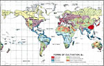
Forms of Cultivation, 1915
A map from 1915 showing the various forms of agricultural cultivation and land use across the world. This map is color–coded to show regions of horticulture, agriculture, plantations, primitive cultivation, stock–rearing grounds, and hunt...

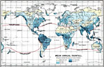
Mean Annual Rainfall, 1915
A map from 1915 showing the mean annual rainfall throughout the world. This map is color–coded to show areas where the number of inches of rainfall ranges from below 10 inches to above 75 inches. Within each colored area, figures show the avera...

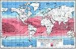
Ocean Surface Temperature, 1915
A world map from 1915 showing ocean surface temperatures across the earth. The map shows isotherm lines of mean annual temperatures given in degrees Fahrenheit, and is color–coded to show cold temperatures from below 40° to 60° F. (blue...

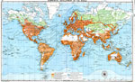
Commercial Development of the World, 1915
A map showing commercial development throughout the world in 1915. This map is color-coded to show land areas at the time engaged in international commerce (dark orange), regions capable of commercial development, but at the time undeveloped (light o...

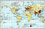
Density of Population, 1915
A world map from 1915 showing density of population throughout the world. This map is color–coded to show uninhabited regions, regions of population with density under 1 person per square mile, to regions of population density of over 400 perso...

Races of Mankind, 1915
A map of the world from 1915 showing the ‘Races of Mankind’ according to the social norms of the time. The map is color–coded to show regions of white, yellow, and black &slquo;types,’ and areas of mixed–races....

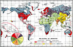
Religions of Mankind, 1915
A map from 1915 showing the religious regions of the world. The map is color–coded to show the regions of predominately Protestant, Catholic, Eastern Church (Greek, Armenian, Abyssinian), Mohammedan, Buddhist, Brahmin, and Heathen religions, wi...

First Previous Next Last


  Maps > Globes and Multi-continent > Complete Maps
Site Map  

Maps ETC is a part of the Educational Technology Clearinghouse
Produced by the Florida Center for Instructional Technology © 2009
College of Education, University of South Florida