Record
221 to
230 of
316
A collection of world and multi-continent maps, including various projections, hemispheric maps, physical and political maps, early known world maps, climate maps, relief maps, ocean current maps, population density and distribution maps, vegetation maps, and economic/resource maps.
|
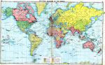
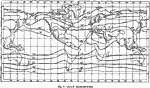
Political Divisions of the World,
1915
A map from 1915 showing the political divisions of the world at that time on a Mercator's Projection. This map is color–coded to show territories and islands under possession of the British Empire, United States, German Empire, Russian Empire, ...
|
|
The Distribution of Younger Fold Mountains,
1915
A world map from 1915 showing the distribution of younger fold mountains across the earth. Folding refers to the compression process of mountain–building (opposed to rifting or pulling apart), and ‘Younger&rlqou; refers to the later 10 to...
|
|
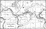
The Distribution of Volcanoes,
1915
A world map from 1915 showing the distribution of volcanoes and belts of volcanic activity across the earth. The map shows areas of existing volcanoes in black, belts of existing volcanic activity in hatchures, and belts of extinct activity. The map ...
|
|
January Isotherms,
1915
An isothermal chart of the world from 1915 showing typical temperature patterns for the month of January. Temperatures are shown on the isotherms, given in degrees Fahrenheit....
|
|
July Isotherms,
1915
An isothermal chart of the world from 1915 showing typical temperature patterns for the month of July. Temperatures are shown on the isotherms, given in degrees Fahrenheit....
|
|
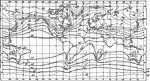
January Isobars and Wind Direction,
1915
A world map from 1915 showing typical global isobars and winds during January. Barometric pressures are shown on the isobar lines. Typical wind directions are shown flying with the arrowheads, away from high pressure and towards low pressure areas....
|
|
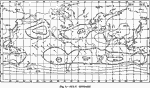
July Isobars,
1915
A world map from 1915 showing typical global isobars and winds during January. Barometric pressures are shown on the isobar lines. Typical wind directions are shown flying with the arrowheads, away from high pressure and towards low pressure areas....
|
|
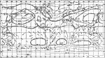
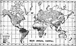
Worldwide Mean Annual Rainfall,
1915
A world map from1915 showing mean annual rainfall across the earth. The map is shade–coded to show regions where mean annual rainfall is 10 inches or less in light stippling, up to 40 inches in light gray, up to 80 inches in dark gray, and over...
|
Maps ETC is a part of the Educational Technology Clearinghouse
Produced by the Florida Center for Instructional Technology © 2009
College of Education, University of South Florida