Record
271 to
280 of
316
A collection of world and multi-continent maps, including various projections, hemispheric maps, physical and political maps, early known world maps, climate maps, relief maps, ocean current maps, population density and distribution maps, vegetation maps, and economic/resource maps.
|
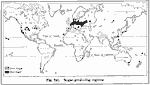
Sugar Production,
1916
A world map from 1916 showing the principal sugar-producing regions of the world at the time. This map shows regions of cane sugar with hatchures, and beet sugar in black. Sugar production is based on five-year averages; "World’s annual crop, Ca...
|
|
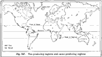
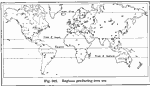
Tea and Cacao Production,
1916
A world map from 1916 showing the principal tea and cacao–producing regions of the world at the time. This map shows regions of tea with hatchures, and cacao in black. No figures for cacao–production are given in the text. Tea production ...
|
|
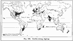
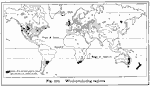
Cattle-Raising Regions of the World,
1916
A world map from 1916 showing the principal cattle–raising regions of the world at the time. The areas of heaviest production are shown in solid black. "World’s total (excepting China), 500,000,000. The leading cattle–raising countri...
|
|
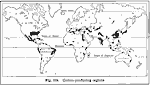
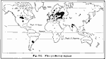
Cotton Production,
1916
A world map from 1916 showing the principal cotton–producing regions of the world at the time. Based on five–year averages; "World’s annual production, 22,000,000 bales of 500 pounds each. Leading cotton–growing countries, with...
|
|
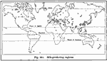
World Wool Production,
1916
A world map from 1916 showing the principal wool-producing regions of the world at the time, showing areas of production in hatchures, with the regions of heaviest production in black. Based on five-year averages; "World’s annual exports of wool...
|
|
Silk Production,
1916
A world map from 1916 showing the principal silk–producing regions of the world at the time. Based on five–year averages; "It is impossible to obtain accurate figures of the world production of raw silk, as the records of production ...
|
|
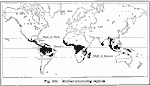
Rubber Production,
1916
A world map from 1916 showing the principal rubber–producing regions of the world at the time. Based on three–year averages; "World’s annual production, 600,000,000 pounds. Leading sources of rubber, with percentages of world product...
|
|
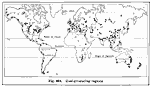
Flax Producing Regions of the World,
1916
A world map from 1916 showing the principal flax–producing regions of the world at the time. "Flax (fiber). World production, about 1,400,000,000 pounds a year. Reliable statistics are not now available. Before the World War, about 80% of ...
|
|
World Coal Production,
1916
A world map from 1916 showing the principal coal–producing regions of the world at the time. "World’s annual production, 1,350,000,000 short tons. Leading coal–producing countries, with percentages of world production: United States ...
|
|
Iron Production,
1916
A world map from 1916 showing the principal iron ore producing regions of the world at the time. "World’s annual production of pig iron, 70,000,000 long tons. Countries leading in the production of pig iron, with percentages of world production:...
|
Maps ETC is a part of the Educational Technology Clearinghouse
Produced by the Florida Center for Instructional Technology © 2009
College of Education, University of South Florida