|
|
|
| Maps > Globes and Multi-continent > Complete Maps |
A collection of world and multi-continent maps, including various projections, hemispheric maps, physical and political maps, early known world maps, climate maps, relief maps, ocean current maps, population density and distribution maps, vegetation maps, and economic/resource maps.

|
Mercator's Projection of the World,
1909 |
|
Lambert's Projection of the World,
1909 |

|
Polar Projection of the World,
1909 |
|
World Annual Rainfall,
1909 |
|
Average World Tobacco Production,
1909–1913 |
|
The World on Mercator's Projection ,
1910 |
|
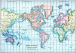
The World,
1910 |
|
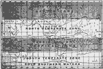
A Map of the Climate Zones,
1910 |
|
Wind Belts of Earth,
1910 |

|
Mean Annual Rainfall of the World,
1910 |
| First | Previous | Next | Last |
| Maps > Globes and Multi-continent > Complete Maps |
Maps ETC is a part of the Educational Technology Clearinghouse
Produced by the Florida Center for Instructional Technology © 2009
College of Education, University of South Florida