| Maps > United States > Virgina |
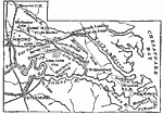 |
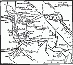
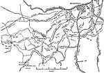
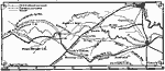
Map of the Peninsula, A map of eastern Virginia during the Civil War. |
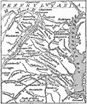 |
Seat of War in Virginia, A map showing the seat of the Civil War in Virginia. |
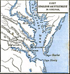 |
First English Settlement in Virginia, 1492-1620 Map shows First English Settlement in Virginia. |
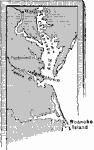 |
Jamestown, 1609 A map showing the early colony of Jamestown. |
 |
Virginia in 1652, 1652 A map of Virginia in 1652, showing the counties and dates of their formation. |
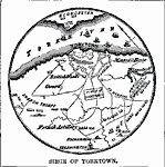 |
Siege of Yorktown, 1781 A map showing the seige of Yorktown during the American Revolution. |
 |
Siege of Yorktown, 1781 A map showing the siege of Yorktown during the American Revolution. |
 |
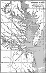
Virginia Coast, 1783 A map showing Virginia and part of Maryland. |
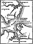 |
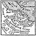
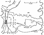
Vicinity of Fortress Monroe, 1861 Map of the vicinity of Fortress Monroe in 1861. |
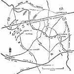 |
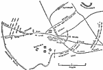
Map of the First Battle of Bull Run, July 21, 1861 A map showing the First Battle of Bull Run on July 21, 1861. The battle took place near the town of Manassas, Virginia, and is also known as the First Battle of Manassas. |
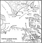 |
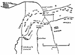
Norfolk, 1862 A map of Norfolk, Hampton Roads, and the vicinity, showing where the Merrimac was burnt and sank. |
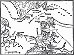 |
Hampton, 1862 A map of Hampton Roads, here occured the first engagement between ironclads. |
 |
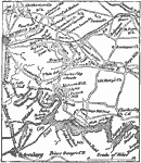
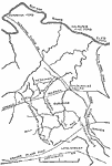
Seven Day's Fighting, 1862 The field of operations during the Seven-Days' Fighting. |
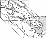 |
Virginia, 1862 A map showing the eastern region of Virginia. |
 |
Map of the Battle of Fair Oaks, 1862 A map showing the battle of Fair Oaks, Virginia, which took place on May 31-June 1, 1862. |
 |
Map of the Battle of Seven Days, 1862 A map showing the battle of Seven Days near Richmond, Virginia. The battle took place June 26-July 2, 1862. |
 |
Vicinity of Richmond and Petersburg, 1862 A map showing the vicinity of Richmond and Petersburg during the Civil War. |
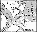 |
Ft. Monroe and Norfolk, 1862-1863 A map showing Ft. Monroe and Norfolk, as well as Hampton Roads, where the Monitor and the Merrimac fought. |
 |
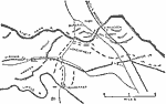
Map of the Battle of Williamsburg, May 1862 A map showing the battle of Williamburg, Virginia, which took place on May 5, 1862. |
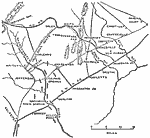 |
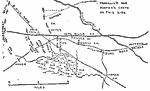
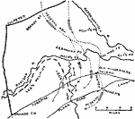
Map of Pope's Campaign, August 24, August 24, 1862 A map showing Pope's campaign in the Bull Run area on August 24, 1862. |
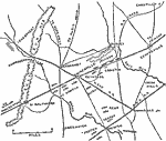 |
Map of Pope's Campaign, August 28 A.M., August 28, 1862 A map showing Pope's campaign in the Bull Run area on the morning of August 28, 1862. |
 |
Map of Pope's Campaign, August 29, Noon, August 28, 1862 A map showing Pope's campaign in the Bull Run area at Noon, August 29, 1862. |
 |
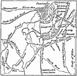
Map of Fredericksburg, December 13, 1862 Battle of Fredericksburg, Virginia in the American Civil War. |
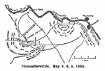 |
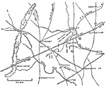
Chancellorsville, May 1863 Battle of Chancellorsville in the American Civil War. May 3, 4, 5 shown. |
 |
Chancellorsville, May 2, 1863 Battle of Chancellorsville in the American Civil War. May 2 shown. |
 |
Mine Run, November 1863 The region near the Rappahannock river in Virginia, site of the Mine Run campaign. Map shows November 26-30, 1863. |
 |
Siege of Petersburg, 1864 A map showing the vicinity of Petersburg during the siege that took place through the Civil War. |
 |
Cold Harbor, 1864 Map of the region near the Cold Harbor, Virginia. Site of the Battle of Cold Harbor. Map shows May 31- June 12, 1864. |
 |
Operations around Petersburg, 1864-1865 Map of region surrounding Petersburg, Virginia. Site of the Battle of Petersburg and the Siege on Petersburg. Map shows June 1864-April 1865. |
 |
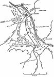
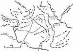
Battle of the Wilderness, May 1864 The region near the Rapidan River in Pennsylvania, site of the Battle of the Wilderness. The map shows the area as it was on May 5-6, 1864. |
 |
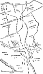
Battle of Spotsylvania, May 1864 The region surrounding the Spotsylvania Court House. Site of the Battle of Spotsylvania. Map shows May 8-21, 1864. |
 |
North Anna, May 1864 Map of the region near the North Anna river. Site of the Battle of North Anna. Map shows May 23-26, 1864. |
 |
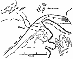
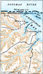
Winchester, September 19, 1864 Map of Winchester, Virginia and the surrounding region. Site for the Battle of Opequon, also known as the Third Battle of Winchester. Map shows September 19, 1864. |
 |
Fisher's Hill, September 22, 1864 Map of the region surrounding Strasburg, Virginia. Site of the battle of Fisher's Hill. Map shows September 22, 1864. |
 |
Virginia, 1865 A map showing the region where the closing days of the Civil War were fought. Appomattox Courthouse (where Lee surrendered) is also shown. |
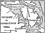 |
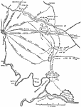
Vicinity of Jamestown, 1872 Jamestown is on the north side of James river, 30 miles from its mouth, and 8 miles S.S.W. from Williamsburg. |
 |
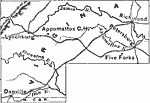
Appomattox Court House, 1881 A map showing the area around Appomattox Court House, the scene of Lee's surrender. |
 |
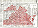
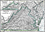
Virginia, 1906 Map of Virginia in 1906. |
 |
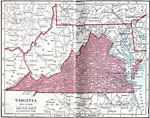
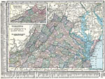
Virginia, 1912 A map of Virginia in 1912. |
 |
Section of the Virginia Coast, 1916 A map of a section of the Virginia coast, showing land made rough by the work of streams. |
 |
Virginia, 1919 A map of Virginia, showing cities and railroad routes. |
 |
Virginia, 1920 Map of Virginia. |
 |
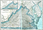
Virginia, 1920 Physical map of Virginia with a map insert of the western part of Virginia. |
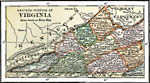 |
Western Virginia, 1920 The western portion of Virginia. |
 |
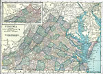
Virginia, 1922 Physical map of Virginia. |
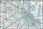 |
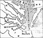
Richmond - Norfolk, 1922 Richmond, Norfolk and neighboring counties. |
| Maps > United States > Virgina |
Maps is a part of the Educational Technology Clearinghouse
Produced by the Florida Center for Instructional Technology © 2007
College of Education, University of South Florida